
HONOR AWARD
Represents outstanding accomplishment in the profession of landscape architecture.

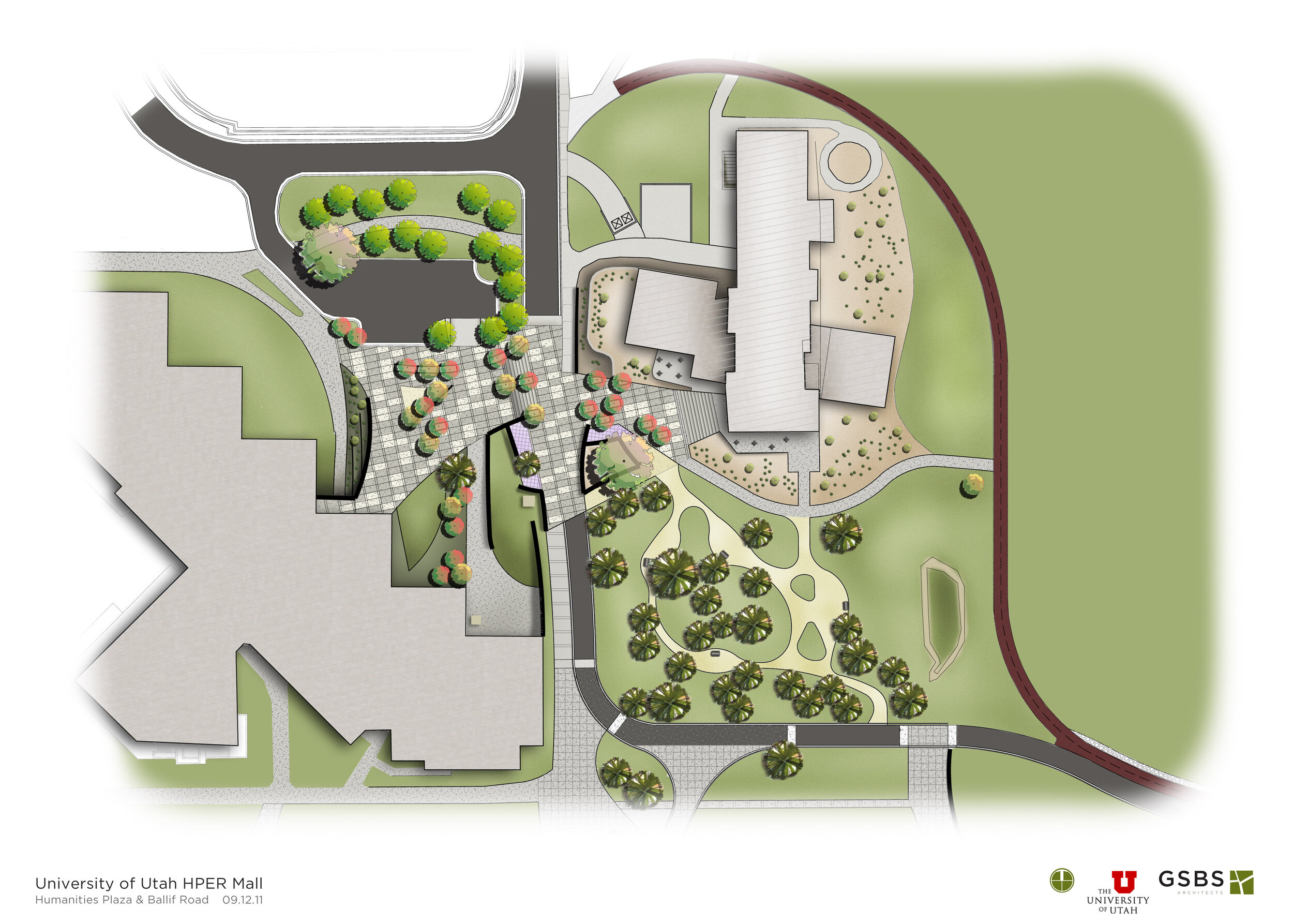
HYPR MALL
“Cohesive design and well thought through circulation, managing stormwater and following contours. We hope these concepts are followed through in construction.”
PROJECT NARRATIVE
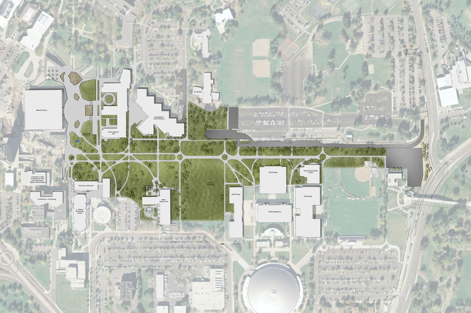
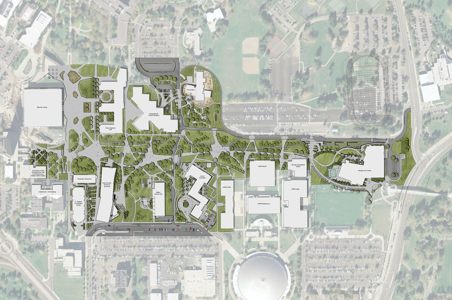
The goal the 2014 HPER Mall Master Plan is to integrate and enhance current, under-construction and future building projects along the mall. The plan creates two distinct landscape vocabularies, each with the objective of siting a building aesthetically and responsibly in the site and creating a design guide for landscape enrichments.
The first is a natural, predominantly native landscape that speaks both to sustainability and the beauty of the indigenous landscape of the northern Utah foothills. The second stands in contrast to the natural and consists of a more manicured, campus-like aesthetic that enhances entrances and defines circulation patterns and connection to the broader walkable-campus concept in an accessible way. The HPER Mall Master Plan aims to enhance the student and visitor experience as they arrive at the site, enter facilities, and use outdoor spaces. Landscape materials are planned to speak to the existing site conditions, compliment the buildings’ materials in color, texture, and size, and will be well suited to the harsh weather conditions of northern Utah.
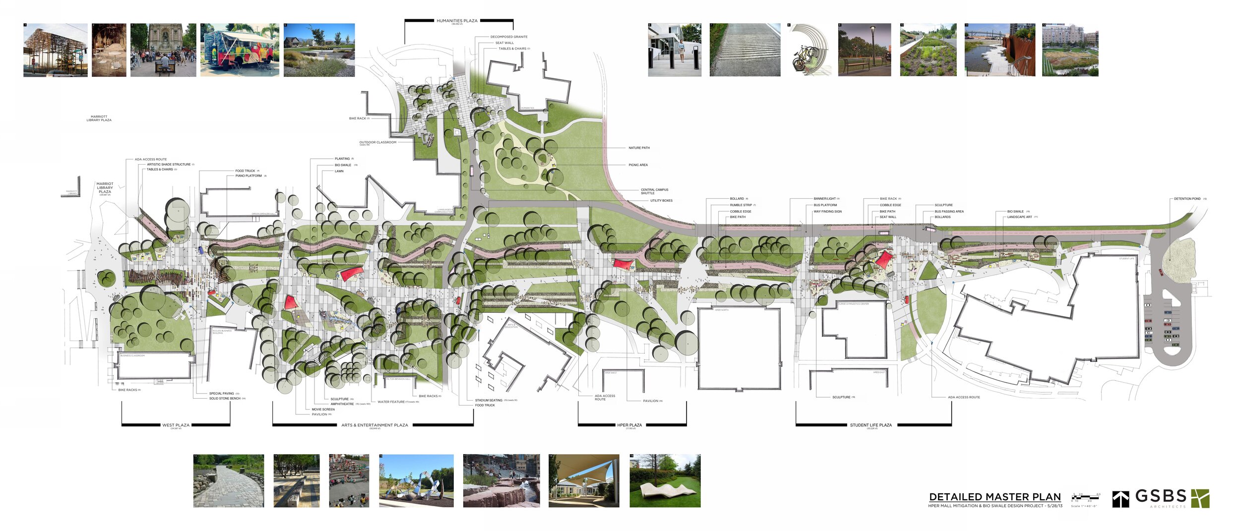
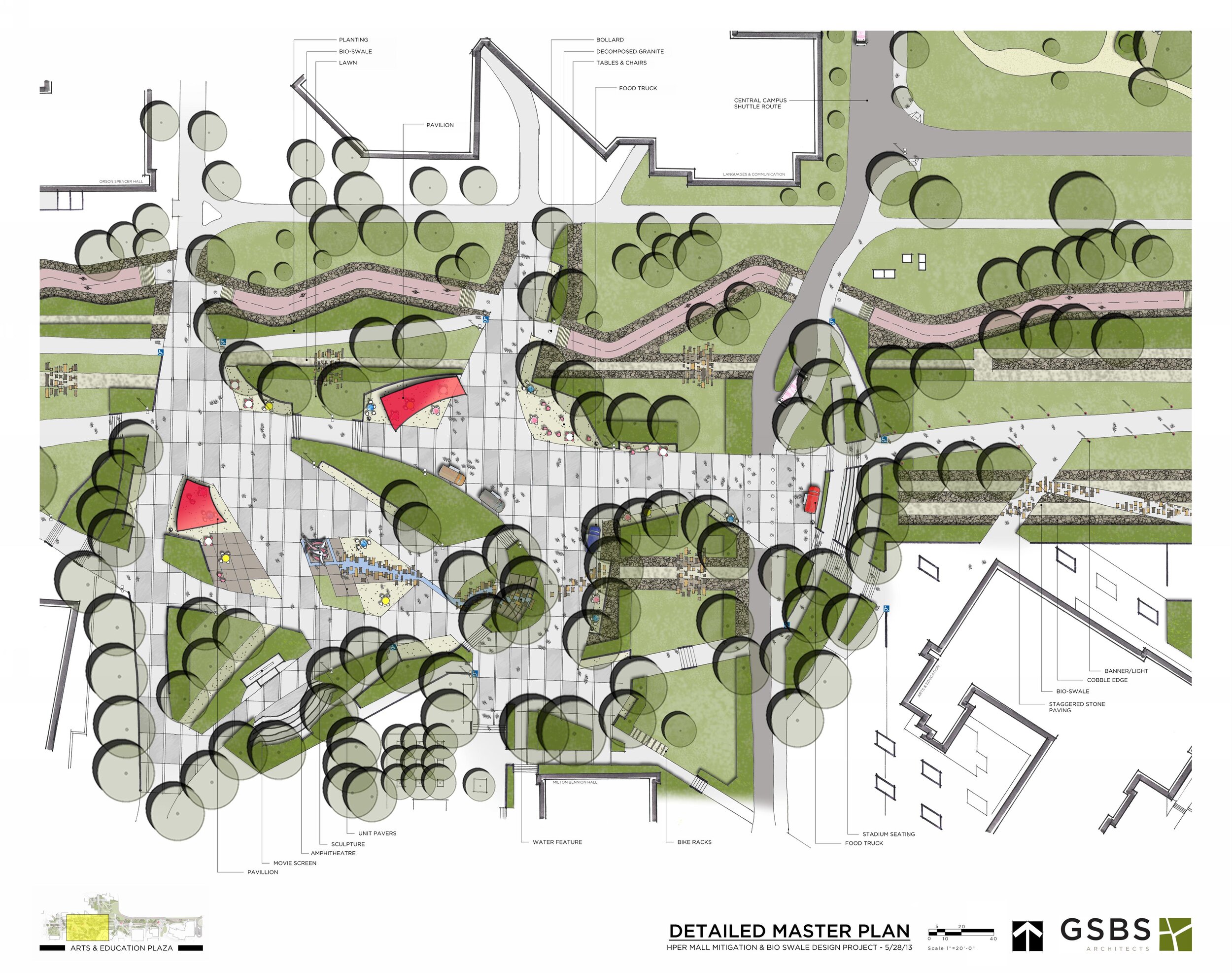
The University of Utah continues to make the shift from a commuter campus to a public transportation campus. The HPER Mall will connect the campus east to west with easily identified pathways for all types of traffic; will help the students safely and easily move between buildings; provide new spaces for gathering and for easy access to buildings already existing along the mall as well as new projects slated for the mall. The natural routes that the students now take along the HPER Mall were incorporated into the master plan and where pathways intersect plazas were created, designed to accommodate flexible travel routes. Paving materials provide intuitive cues to the location of passive and active travel areas.
The project design gives a sense of progressiveness, uses campus standards, uses large pieces of naturally occurring red sandstone to knit the bio-swale to its surroundings, uses organized natural and native plant material, compliments the needs of student learning by providing places for meeting, studying or commuting, respects the function of maintenance on a large campus by identifying areas.
The existing topography presented some challenges in meeting established building elevations and current ADA requirements. We solved it by running access ramps at minimal grades following the natural contours and stairways on steeper grades for pedestrians.
The HPER Mall is an extensive pedestrian mall in the center of the University of Utah campus with significant pedestrian, skateboard, bicycle, maintenance vehicles and shuttle bus traffic. The University embarked on a project to install utility tunnels below the surface of the HPER Mall which would eliminate all walk ways and site features along most of the length of the mall. The consultant team and the University of Utah developed solutions for resolving the complex and conflicting patterns of movement as well as integration of a bioswale and multi-step storm water system in the midst of the Mall. This process removed all walk ways and site features along the mall. This project literally and figuratively “stitched” together the incision of the HPER Utility Tunnel into the HPER Mall.
The plan provides connectivity to the campus and a convenient and safe route for all types of traffic, while providing environmentally sensitive mitigation for the extensive damage done during construction of the utility tunnel. The HPER Mall has grade changes of 5%-10%. This renovation project provides dedicated space for pedestrians, bicyclists, boarders, campus shuttle, and maintenance vehicles and includes outdoor rooms.
This plan is the first step in the development and implementation of the Campus Bicycle Master Plan, the coordination of the Campus Signage Master Plan and a significant part of Transformative Projects of the 2008 University of Utah Campus Master Plan.
Due to the complexity of this project, the consultant team used an Integrated Design Process (IDP), bringing the campus representatives, landscape architect, contractors, and consultants together to foster an efficient decision-making process during the initial stages of design. The benefits of an integrated approach include the creation of a cohesive team early in the design process, transparency in decision making, the inclusion of all good ideas into the design process, the acceleration of the design schedule and efficient management of the design efforts.
Pavements were selected and site furnishings for their compatibility with the themes colors and styles expressed in existing architecture and chose materials for durability and aesthetic value. The design of pavements in pedestrian zones define gathering and circulation spaces and are composed of materials of a finer scale and texture that speak to a campus-like level of detail.
The goal of the irrigation design was to control the amount, frequency and duration of applied water to the site landscape. We anticipated a 65% uniform distribution would be achieved with an 80% irrigation efficiency. Evapo-transpiration will be reduced by the use of drought-tolerant plant materials.
Landscape plant materials are to be composed of a mixture of native deciduous and evergreen shrubs, trees, drought tolerant grasses, and perennials. We selected plant materials for suitability to the site and climate, form and structure, year-round interest and foliage color. We placed them in such a way as to frame out views, identify circulation corridors, and provide shelter from cold winds in the winter and shade in the summer.
It is the design team’s goal to manage all of the storm water runoff from the buildings and site, therefore contributing no additional water to the city’s storm water system. Storm water is surface drained from the parking and walking surfaces into drainage ways or bio-swales where they discharge into the ground. Water captured in these basins slowly percolate into the ground recharging the water table.
The Master Plan calls for a phased approach to implementation. The first phase of the plan was funded through general funds and funds from the HPER and USTAR utility tunnels construction budgets. Additional phases will be implemented according to available funding sources. New buildings that develop on the Mall have the associated segments of the Mall plan included in each project’s budget.
We designed five distinct plaza areas on the Mall. These have places to sit, water features, art, Wi-Fi, kiosks and information booths, and shade structures. Students can use these plazas as meeting points, study spots, lunch spots, serving as outdoor rooms.
The construction of the Red Asphalt bike path, the Dumke Plaza, the HPER East Plaza, and the LNCO Plaza initiated the separation of bike and pedestrians. The plazas, with their spaces and pathways that link them, were also part of the first phase.
Plazas were defined with concrete scoring, porous paving, new Campus Standard pedestrian lighting, and stainless-steel handrails. Additionally, the realignment of the former Ballif Road and parking lot provided additional safety by separating the “thruway” bike route, and the Central Campus Shuttle route. These elements required close coordination between Campus Police, Campus Design and Construction, Physical Facilities, maintenance, Bike Coalition, Commuter Services, and various University College administrators.
The bike path has switchbacks for speed control, the path changes color and texture, and has stop signs where it intersects plazas. The footpath has a rough surface for traction and the main thoroughfare is wide enough for snow removal equipment. There are emergency buttons all along the Mall, which connect to campus police and the Mall is well-lit and open.
The new plan for the HPER Mall creates zones for public transportation – the Shuttle – as well as bikers, boarders and pedestrians. The project team studied the natural paths taken by each of these groups and created separate pathways based on those trends. Wayfinding and signage mark shuttle routes and stops. Plazas built into the mall correspond to the buildings lining the mall.